Trips and Routes
Upper Mad
Madawaska River - Needs Description
Middle
Madawaska River - The middle Mad is the perfect river to learn and progress you paddling skills. Is is top dam released allowing for warm water in the summer. There are many dynamic eddies and small wave and hole features. There are many options for alternative Put-Ins and Take-Outs.
Lower Mad (Aumond to Buck Bay)
Madawaska River - A quintessential whitewater canoe river: beautiful scenery, many moderate rapids suitable for novice ww paddlers, fun play at high water, beautiful campsites and a long season.
Cherry Point Park To Burnstown
Madawaska River - While the Madawaska has many rapids further upstream, this section is largely flatwater exception the spring and high water situations (heavy rainfall and peak hydropower demand) when a class 1-2 rapid develops around Springtown, midway to Burnstown. There is a steady current downstream so it is recommended that you plan a one-way trip and set up a shuttle at the public beach in Burnstown
Burnstown Launch
Madawaska River - This is a particularly scenic flatwater
stretch of the Madawaska River and there is a public beach, which is
an ideal put-in for paddle trips, located 500 m east of Burnstown on
Hwy 508. You put in and take out from the same launch for this trip.
Palmer Rapids
Madawaska River - The Palmer Rapid section is just up stream from Paddler Co-op and consists of two sets of rapids with a nice pool in between. It is a nice spot to run laps of both sets, with an easy portage from the put in to the take out or to park and play at your favourite feature.
Great for beginner and intermediate paddlers.
---
Palmer Rapids is one of the best and most reliable sets of whitewater to learn on throughout the year. There is a dam above Palmer Rapids which has an online gauge providing daily updates on the river level. Below the dam are 3 different channels of whitewater which flows into a calm pool before flowing into the lower set, which is about 200m of continuous rapids. There is a portage at Pine Point (river left side) which provides access to the entire stretch of river. Paid river access on the Jessups' property is available on the river right side via River Bend Road.
-written by Jack Jardeleza about this run
Stay Connected. Get the PaddlingMaps app today!


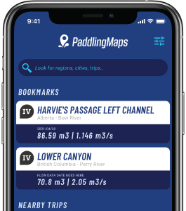
Get the trip info you need,
when you need it most.
- Save bookmarks for offline access
- View trip details
- View river flow data
- View trip feature map