Trips and Routes
Fitzstubbs Canyon
Fitzstubbs Creek - Fitzstubbs was long regarded as a "no go" zone for the reason of having several large and questionable waterfalls stacked within a remote canyon. Eventually, separate groups of curious paddlers found the levels and lines needed to put Fitzstubbs on the hucker's map. A tributary to Wilson Creek, Fitzstubbs can be run alone, or combined with Wilson Creek (entering just below the 11km put-in) making for a 20km journey. Ideal levels are generally based on when Wilson is running med or lower, but not too low.
Stay Connected. Get the PaddlingMaps app today!


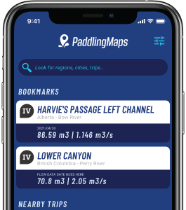
Get the trip info you need,
when you need it most.
- Save bookmarks for offline access
- View trip details
- View river flow data
- View trip feature map